 LUNAR Events
LUNAR Events
LUNAR Events LUNAR Launches
Our monthly launches at Snow Ranch are held on the first saturday of the month when there is no fire danger. See the online calendar for details.
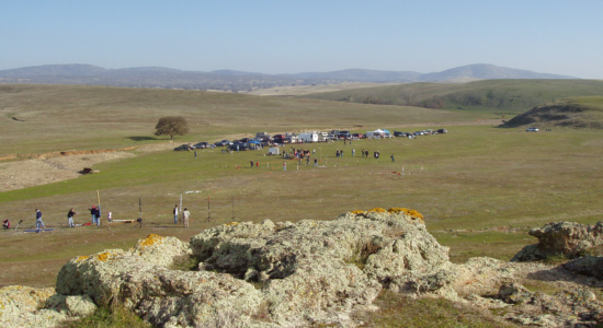
The Snow Ranch launch site is located on highway 4 about 30 miles east of Stockton. Here is a rockets eye view of the launch site by Jamie Clay and a topographic map of the area (the map is centered on the launch site). The Ranch is about an hour drive from Livermore. The field is certified Level 3 with a 15,000 foot ceiling. We are currently allowing up to M motors on that field though you will need to get LUNAR board approval before flying L or M class engines. The Snow Ranch (http://www.orvisranch.com) launch site is a field on an operating cattle ranch so normal ranch rules apply.
There are no amenities at the field so bring everything that you will need. We will rent a porta potty for the event.
LUNAR has a Rocket Hunter radio locator receiver you can use to find lost rockets. You must supply the transmitter. See the Radio Locator page for more information.
Note, however, that you can only count on flying motors up through "G" on a drop-in basis. Flying "H" and larger motors requires both HPR Level 1 certification (NAR or TRA) and the presence of a licensed Class III Pyrotechnician to supervise the flight. There are a few licensees in the club, so it is likely (but not guaranteed) that one will be on hand at any given launch.

Image courtesy BenitoLink
The Brignatino Park Launch Site is located in Hollister, CA, about an hour south of the Bay Area. Launches are limited to low- and mid-power (A through G motors) with a maximum altitude of 1000 feet.
The launch location on this field is about 200 yards from the parking lot. You will not be able to easily operate out of your car so be prepared to haul your rockets, tables, chairs, etc. to the launch location. A wagon would be very useful. Bathrooms are available by the parking lot.
Non-members are charged a $10/day flying fee to help cover our costs for insurance and equipment maintenance. However, if you are going to be flying with us more than once during the year is is usually less expensive to join LUNAR.
ContestsOnce or twice a year we hold sanctioned contest launches
for points in the NAR national contest standings.
These are often organized in conjunction with other rocket clubs
in the area (BayNar,
AeroPac) but you
don't have to be a member of any of them (or even
the NAR) to participate. You are welcome to join just for the
spirit of competition! See the
contest calendar for a list of dates.
In keeping with our youth education and community involvement
charter, LUNAR will support, where possible, the
rocketry activities of community youth groups. We have in the
past supported launches (and in some cases building
sessions) for the Scouts, 4H, Indian Guides, Livermore Science
Camp and local schools. For these launches, the
young people are not required to join or be members of the
club, and each will receive 3 free flight cards for
the day of the launch. Please contact one of the club officers
for further details and to make arrangements for
your club. LUNAR section meetings take place every other month.
See the online calendar for
dates and topics. A typical LUNAR meeting covers club business, followed by a
presentation by a club member and/or visiting expert
on some aspect of rocketry, ranging from simple building tips
to advanced science and engineering principles. The meetings are held at the Maker Nexus in Sunnyvale or the Greenmeadow Neighborhood Community Room in Palo Alto. Consult the
calendar to see where the next meeting is being held and the
directions page to see how to get there. In addition to teaching rocketry in the schools and for
Scouts, 4H, and other organizations, LUNAR members promote rocket
science at local Air Shows, Model Rocketry meets, and other public
gatherings.
The
Snow Ranch is located about 30 miles east of Stockton on highway 4.
turn in at the stone gateposts shown here.
Road on the ranch from the highway to the launch site. Take I-80/580/680 (whichever is closer to you) to State Route 4 and head east.
Continue on 4 all the way to Stockton where it goes north on I5 one exit and then east to 99.
Go south on the combined 4/99 one exit to Golden Gate avenue. Go left at the end of the exit ramp onto
Golden Gate avenue and stay on it
as it turns into Highway 4.
Continue east on 4 and in about 17 miles you'll come to Farmington. This is your
last chance to buy food, gas or other supplies.
Continue about 10 miles further on 4 east and you will cross the Milton-Eugene road.
About 1 mile beyond the Milton-Eugene road, Highway 4 bends slightly to the right.
On your left you will see two stone gateposts. This is the entrance to Snow Ranch
(the sign reads Orvis Cattle Company). Turn in and travel up the driveway until
you reach the houses and garages. Turn right immediately before the garage, go
over the cattle guard and follow the road into the field. A few hundred feet beyond
the cattle guard the road branches. Take the right branch and continue about one mile
to the launch site. There is a gate about halfway along that you must open, and be sure
to close and re-latch it after you have passed. CAUTION! Stay only on the road.
The land on either side can be very soft and a car (even a 4WD) can easily get stuck. Take 580 east over the Altamont Pass. Continue straight when 580 splits off to
the right and the road changes to 205. Continue on 205 until it merges with I-5
north in Tracy. About 10 miles up I-5 you will come to the junction with SR 4.
Take 4 east (thats the second 4 exit, the first one is west) about three miles
where it merges with 99. Go south on the combined 4/99 one exit to Golden Gate avenue.
Go left at the end of the exit ramp onto Golden Gate avenue and stay on it
as it turns into Highway 4. Continue east on 4 and in about 17 miles
you'll come to Farmington. This is your last chance to buy food, gas or other supplies.
Continue about 10 miles further on 4 east,
and you will cross the Milton-Eugene road. About 1 mile beyond the Milton-Eugene road,
Highway 4 bends slightly to the right. On your left you will see two stone gateposts.
This is the entrance to Snow Ranch (the sign reads Orvis Cattle Company).
Turn in and travel up the driveway until you reach the houses and garages.
Turn right immediately before the garage, go over the cattle guard and follow the
road into the field. A few hundred feet beyond the cattle guard the road branches.
Take the right branch and continue about one mile to the launch site. There is a
gate about halfway along that you must open and be sure to close and re-latch it
after you have passed. CAUTION! Stay only on the road. The land on either side can
be very soft and a car (even a 4WD) can easily get stuck. Take I-680 north over the Mission Grade. After you're on the far side of the grade,
you have a choice of continuing up I-680 to I-580, or taking SR 84 to Livermore and through
town to I-580. The 84 cutoff through livermore now bypasses downtown and connects directly to
I-580, making it much faster.
Once on 580 east, continue over the Altamont Pass. Continue straight when
580 splits off to the right and the road changes to 205. Continue on 205 until it merges
with I-5 north in Tracy. About 10 miles up I-5 you will come to the junction with SR 4.
Take 4 east (thats the second 4 exit, the first one is west) about three miles where
it merges with 99. Go south on the combined 4/99 one exit to Golden Gate avenue.
Go left at the end of the exit ramp onto Golden Gate avenue and stay on it
as it turns into Highway 4. Continue east on 4 and in about 17 miles you'll come to Farmington.
This is your last chance to buy food, gas or other supplies.
Continue about 10 miles further on 4 east, and you will cross the Milton-Eugene road.
About 1 mile beyond the Milton-Eugene road, Highway 4 bends slightly to the right.
On your left you will see two stone gateposts. This is the entrance to Snow Ranch
(the sign reads Orvis Cattle Company). Turn in and travel up the driveway until
you reach the houses and garages. Turn right immediately before the garage, go over
the cattle guard and follow the road into the field. A few hundred feet beyond the
cattle guard the road branches. Take the right branch and continue about one mile to
the launch site. There is a gate about halfway along that you must open, and be sure
to close and re-latch it after you have passed. CAUTION! Stay only on the road.
The land on either side can be very soft and a car (even a 4WD) can easily get stuck. From anywhere in the Central Valley, take I-5 towards Stockton.
On the south side of Stockton is the junction with SR 4. Take 4 east about three
miles where it merges with 99. Go south on the combined 4/99 one exit to Golden Gate avenue.
Go left at the end of the exit ramp onto Golden Gate avenue and stay on it
as it turns into Highway 4. Continue east on 4 and in about 17
miles you'll come to Farmington. This is your last chance to buy food, gas or other
supplies. Continue about 10 miles further
on 4 east, and you will cross the Milton-Eugene road. About 1 mile beyond the
Milton-Eugene road, Highway 4 bends slightly to the right. On your left you will
see two stone gateposts. This is the entrance to Snow Ranch (the sign reads Orvis Cattle Company).
Turn in and travel up the driveway until you reach the houses and garages.
Turn right immediately before the garage, go over the cattle guard and follow
the road into the field. A few hundred feet beyond the cattle guard the road branches.
Take the right branch and continue about one mile to the launch site. There is a gate
about halfway along that you must open, and be sure to close and re-latch it after you
have passed. CAUTION! Stay only on the road. The land on either side can be very soft
and a car (even a 4WD) can easily get stuck. The
Brigantino Park is located in Hollister, CA.
and is about an hour south of the Bay Area. The field is 940 feet wide at its narrowist so launches are limited to
low- and mid-power (A through G motors) rockets with a maximum altitude of 1000 feet.
Brignatino Park Take 101 south through Gilroy then take 156 east to 156B (San Juan Hollister Rd.) and go east towards Hollister.
The park is on the west side of Hollister on the south side of San Juan Hollister Rd. LUNAR meetings are held at the Maker Nexxus in Sunnyvale or at the Greenmeadow Neighborhood Community Room, 303 Parkside Drive, Palo Alto, CA Greenmeadow Neighborhood Community Room
LUNAR Education
LUNAR Meetings
LUNAR Promoting Rocket Science Boing Boing at the 11/26/13 LUNAR Launch
LUNAR Bay Area Parent magazine. (January 2009)
LUNAR in the San Francisco Chronicle. (10/19/2007)
LUNAR mentioned in the California Rangeland Trust News. (Fall/Winter 2006)
LUNAR at the EBRC Air Show 2005.
LUNAR at the EBRC Air Show 2003.
LUNAR on Channel 2 News 2/26/2003.
LUNAR on Evening Magazine 11/7/2002.
LUNAR at the EBRC Air Show 2002.
LUNAR highlighted on the Fresh Gear TV show.
LUNAR on the SciSquad TV show.
LUNAR at the East Bay Radio Controllers Aeromodeling Show, October 8, 2000.
Demonstrating model rocketry to the aeromodelers.
LUNAR Goes To The Moon, July 17, 1999,
30 year anniversary of the moon landing.
NAR Regional meet III, 21 April 96
Boing Boing at the 11/26/13 LUNAR Launch
LUNAR Bay Area Parent magazine. (January 2009)
LUNAR in the San Francisco Chronicle. (10/19/2007)
LUNAR mentioned in the California Rangeland Trust News. (Fall/Winter 2006)
LUNAR at the EBRC Air Show 2005.
LUNAR at the EBRC Air Show 2003.
LUNAR on Channel 2 News 2/26/2003.
LUNAR on Evening Magazine 11/7/2002.
LUNAR at the EBRC Air Show 2002.
LUNAR highlighted on the Fresh Gear TV show.
LUNAR on the SciSquad TV show.
LUNAR at the East Bay Radio Controllers Aeromodeling Show, October 8, 2000.
Demonstrating model rocketry to the aeromodelers.
LUNAR Goes To The Moon, July 17, 1999,
30 year anniversary of the moon landing.
NAR Regional meet III, 21 April 96
Directions to the Snow Ranch Launch Site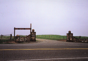
![]() Map of 9601 E Highway 4, Farmington, CA 95230-9607
Map of 9601 E Highway 4, Farmington, CA 95230-9607
View LUNAR Snow Ranch Launchsite in a larger mapNote: The interchange at highways 4 and 99 has changed.
From The North Bay And East Bay From Oakland Northward:
From The East Bay From San Leandro Southward:
From The South Bay:
From The Central Valley:
Directions to the Brignatino Park Launch Site
2100 San Juan Hollister Rd.
Hollister, CA 95023
LUNAR Meeting DirectionsGreenmeadow Community Association
303 Parkside Drive
Palo Alto, CA 94306
Maker Nexus
1330 Orleans Dr
Sunnyvale, CA 94089.
or
Join with Google Meet https://meet.google.com/cwk-qzdx-djg
Or dial: ((US) +1 256-600-8336 PIN: 692 630 4277#
More phone numbers: https://tel.meet/cwk-qzdx-djg?pin=6796402662020
All content is the responsibility of LUNAR.
If you have comments or suggestions regarding these web pages,
please contact the 
Copyright © 1992 - 2026 LUNAR