By Teagan Wall 
NASA JPL
The United States had a rough hurricane season this year. Scientists collect information before and during hurricanes to understand the storms and help people stay safe. However, collecting information during a violent storm is very difficult.
Hurricanes are constantly changing. This means that we need a lot of really precise data about the storm. It’s pretty hard to learn about hurricanes while inside the storm, and instruments on the ground can be broken by high winds and flooding. One solution is to study hurricanes from above. NASA and NOAA can use satellites to keep an eye on storms that are difficult to study on the ground.
In Puerto Rico, Hurricane Maria was so strong that it knocked out radar before it even hit land. Radar can be used to predict a storm’s path and intensity—and without radar, it is difficult to tell how intense a storm will be. Luckily, scientists were able to use information from a weather satellite called GOES-16, short for Geostationary Operational Environmental Satellite – 16.
The “G” in GOES-16 stands for geostationary. This means that the satellite is always above the same place on the Earth, so during Hurricane Maria, it never lost sight of the storm. GOES-16’s job as a weather satellite hasn’t officially started yet, but it was collecting information and was able to help.
From 22,000 miles above Earth, GOES-16 watched Hurricane Maria, and kept scientists on the ground up to date. Knowing where a storm is—and what it’s doing—can help keep people safe, and get help to the people that need it.
Hurricanes can also have a huge impact on the environment—even after they’re gone. To learn about how Hurricane Irma affected the Florida coast, scientists used images from an environmental satellite called Suomi National Polar-orbiting Partnership, or Suomi-NPP. One of the instruments on this satellite, called VIIRS (Visible Infrared Imaging Radiometer Suite), took pictures of Florida before and after the Hurricane.
Hurricane Irma was so big and powerful, that it moved massive amounts of dirt, water and pollution. The information captured by VIIRS can tell scientists how and where these particles are moving in the water. This can help with recovery efforts, and help us design better ways to prepare for hurricanes in the future.
By using satellites like GOES-16 and Suomi-NPP to observe severe storms, researchers and experts stay up to date in a safe and fast way. The more we know about hurricanes, the more effectively we can protect people and the environment from them in the future.
To learn more about hurricanes, check out NASA Space Place: https://spaceplace.nasa.gov/hurricanes/
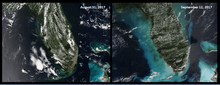
Caption: These images of Florida and the Bahamas were captured by a satellite called Suomi-NPP. The image on the left was taken before Hurricane Irma and the image on the right was taken after the hurricane. The light color along the coast is dirt, sand and garbage brought up by the storm. Image credit: NASA/NOAA
This article is provided by NASA Space Place. With articles, activities, crafts, games, and lesson plans, NASA Space Place encourages everyone to get excited about science and technology. Visit spaceplace.nasa.gov to explore space and Earth science!